SAVANNAH DEVELOPMENT DIVISION · GLOBAL EXCHANGE R&E CORPORATION
Royal Savannah and Diaspora Community Development Trust
The Trust office leads the operations and management of the Savannah Development division. All Zion Trust development projects fall under this office’s management, including the estates, residential and agricultural programs and associated civic, hospitality and community-development projects.
Development applications are received for Trust and development-committee review. Members are welcome to express interest in development committees and board-of-directors selections.
Current construction pricing policy - 16 October 2026
Construction estimate C = measured gross floor area (m²) × applicable Accra benchmark (USD/m²). Resale construction component = C × 1.50. The 50% increase includes the resale markup; it is not a separate inflation reserve. This replaces the previous construction uplift and revenue-margin formula. No additional automatic markup or contingency is stacked on this calculation.
Measure each apartment's practical net area and allocate walls, circulation, cores and common building areas once to determine gross construction area. Existing concept sizes and 70% net-to-gross efficiency are illustrative until measured by the design team; they do not establish code compliance.
Land, site preparation, infrastructure, fixtures/appliances and fitout excluded from the benchmark, professional fees, taxes and financing remain separate, reconciled cost lines. Preliminary combined amount = 1.50 × construction cost + allocated land + other separately established costs. No second markup is assumed on those separate lines. Final sale offers remain pending complete costs and approved layouts.
Owner's latest land planning assumptions: Savannah / Zion Trust Estates US$20,000/acre; in-town Civic Center US$30,000/acre (17 acres = US$510,000); other development land US$25,000/acre. These are owner allowances, not verified acquisition costs or public land offers.
Source: AECOM Africa Property & Construction Cost Guide 2025/26, Accra, page 75; cost date 1 July 2025, FX date 1 May 2025. These are dated published benchmarks, not 2026 Damongo supplier quotations. A 50% cost markup equals 33.33% gross margin on the construction component before excluded costs.
Each alternative uses ten estate acres at US$20,000/acre. Retained concept geometry and category allocations require measured design; alternatives must not be added together. Land and unquoted infrastructure, fitout, fees, tax and finance remain separate. No complete block selling value is asserted.
Damongo city blocks — Draft C
Country-labelled boroughs, heritage streets & an invitation to participate
Explore the revised 25-borough graph with country and community labels, proposed historical and cultural street names, 35 invitation drafts and a researched institutional outreach register. New Kingston retains the five central heritage themes.
Proposed naming for consultation. No foreign-government or community endorsement is implied. Existing land-use reservations and plot IDs remain controlling.
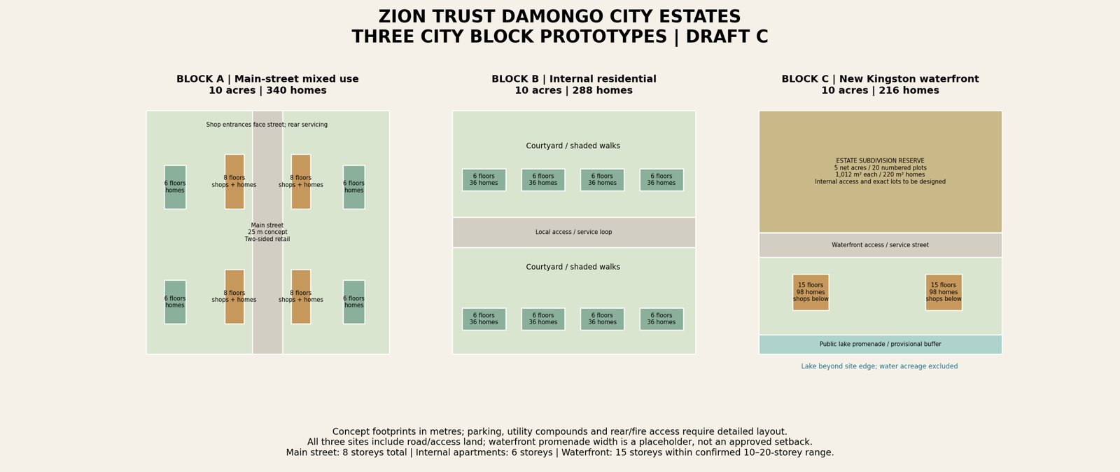
Three 10-acre prototypes for Zion Trust Damongo City Estates. This interprets “three-city blocks” as three repeatable block types, not three new cities. All areas and capacities are design assumptions; these prototypes have not yet been assigned to individual master-plan parcels.
Four 45 × 16 m frontage buildings: ground-floor shops plus seven apartment floors (196 homes); four 36 × 18 m six-storey internal buildings (144 homes).
B — Internal residential
Eight 36 × 18 m six-storey apartment buildings; six homes per floor. Shared courtyards, walking routes and service access.
C — New Kingston waterfront
Two 30 × 30 m 15-storey towers: retail ground floors plus 14 apartment floors (196 homes). Twenty approximately 1,012 m² estate plots with two-storey 220 m² homes (20 homes).
Unit mix and land fit
A/B use an approximately 80 m² average net apartment: 40% one-bedroom at 60 m², 40% two-bedroom at 85 m², 20% three-bedroom at 110 m². Building counts round down floor capacity; actual unit plans must reconcile the mix. A frontage floor accommodates seven units, A/B internal floors six. Tower floors use seven approximately 100 m² net units. No maximum density or architectural optimization is claimed.
A land budget (m²): buildings 5,472; road/service access 8,000; landscape 10,000; surface parking 7,500 (250 bays at 30 m² gross); flexible utilities/setbacks 9,496.56. B: buildings 5,184; access 6,000; landscape 12,000; parking 7,000; flexible 10,284.56. C (revised estate rate): estate plots 20,234.28 (house footprints within plots); towers 1,800; access 6,000; park/promenade 5,000; parking 5,000; flexible 2,434.28. Each totals 40,468.56 m². Parking ratios require a transport study; these are area allowances rather than final parking plans.
Cost basis — USD, indicative concept allowances
Excluded from totals: land/lease, taxes/duties, finance, marketing, inflation beyond stated ranges, bulk/offsite roads and utility plants, lake excavation/dams, schools/hospital and other civic facilities, major earthworks or weak-ground treatment. Local allowances are not a city infrastructure budget. Operations and maintenance require a separate operating model.
Illustrative full-development capacity, not a sales forecast
Of the 720 remaining ten-acre planning blocks, test 144 A blocks, 288 B blocks and retain 288 for employment, civic, education, industry and other nonresidential uses. Test 20 C blocks (200 acres) within New Kingston's 400-acre waterfront-development allocation; reserve 40 acres for the central mall and 160 acres for other attractions/civic/commercial uses. This is a proposed allocation requiring revised zoning, not an approved distribution.
Result: 136,224 homes and about 490,406 residents at full occupancy and 3.6 persons/home. Occupancy sensitivity: 25% ≈ 122,602, 50% ≈ 245,203, 75% ≈ 367,805, 100% ≈ 490,406. Household-size sensitivity at full occupancy: 3.0 gives 408,672, 4.0 gives 544,896. The 3.6 reference is Ghana's provisional 2021 national census figure, not a Damongo forecast: Ghana Statistical Service.
New Kingston central shopping center
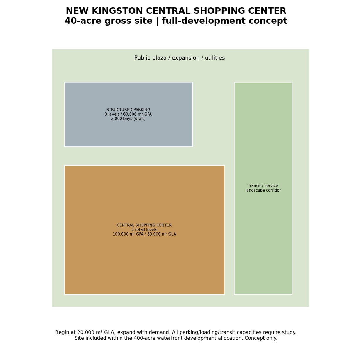
“Housing the community” means serving its shopping and recreation needs, not placing all residents inside at once. Draft retail demand allowance: 0.8 m² net lettable retail per resident, totaling 392,325 m². Distributed street and waterfront commercial space contributes 315,504 m² at assumed 70% letting efficiency. The residual need is rounded to 80,000 m² central-mall GLA, or 100,000 m² GFA at 80% efficiency.
Reserve 40 acres: two mall floors, approximately 50,000 m² footprint; 2,000 structured parking bays at 30 m² gross each (60,000 m² parking GFA across three levels / 20,000 m² footprint); 30,000 m² landscape, 40,000 m² access/loading/transit/utilities and 21,874 m² flexible space. This totals approximately 161,874 m². Size and 2,000-bay count require catchment, tenant and traffic studies. Do not simultaneously count the mall GLA as new residential floor area.
Service plan
At full illustrative population, domestic water at 150 L/person/day plus 20% nonresidential demand and 15% distribution loss gives 103.9 ML/day production. Sewage at 120 L/person/day plus 20% nonresidential demand gives 70.6 ML/day. Residential diversified electricity at 2 kW/home plus 25% nonresidential allowance gives 340.6 MW. These are placeholders, not engineering standards or approved capacities; irrigation, industrial loads and fire flows require separate assessment.
Provide potable-water and fire-water networks, sanitary sewer and wastewater treatment, separate stormwater drains with pretreatment before lake discharge, power substations/backup, telecom ducts, waste collection/recycling, rear shop loading, public transit stops and accessible shaded walks. Main-street buildings need lifts, accessible access, protected egress and separate residential/retail entries; fire-engine access, stair count, hydrants and compartmentation require engineering. Provisional 25 m main-street corridor and 16 m waterfront promenade are drawing placeholders. Flood levels, groundwater, geotechnical constraints and environmental review govern actual lake setbacks. The artificial lake is not assumed to be the potable supply or a sewage outlet.
Next design gates
Confirm surveyed land and contours; reconcile zoning and frontage with the master CAD; establish water balance and lake engineering; prepare architectural floor plans and unit mix; run transport, fire, drainage and utilities models; appoint local architects/engineers and quantity surveyor for priced bills of quantities; phase the first three blocks and mall based on demand. Waterfront estate plots remain conceptual lease/tenure sites; no title or ownership grant is created by this layout.
Regional service reservations — 210 acres
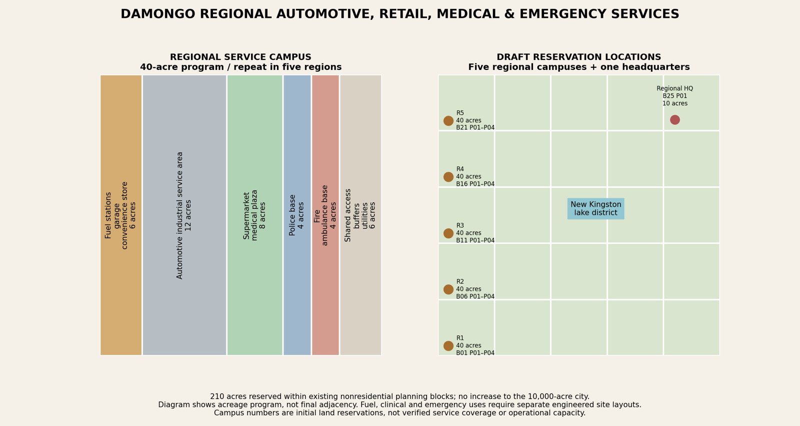
Reserve five 40-acre service campuses, each serving a preliminary five-borough planning region, plus a 10-acre emergency coordination headquarters. These sites occupy 21 existing ten-acre blocks from the 288-block nonresidential allowance; 267 blocks remained before the education/parks/religious allocation below; 238 now remain. Residential capacity assumptions remain 144 mixed-use blocks, 288 residential blocks and 20 waterfront blocks; no service acreage is taken from the lake or added to the city total.
Per regional campus
Acres
Two fuel-station sites, each with service garage and convenience store
6 (2 × 3)
Automotive services: repairs, tyres, parts, fleet maintenance and vehicle inspection
12
Supermarket / medical plaza: retail, pharmacy, outpatient clinic and urgent-care provision
8
Police base and secure operational yard
4
Fire station and ambulance base with separate vehicle bays
4
Shared access, buffers, parking and utilities
6
Per region / five regions
40 / 200
Additional regional coordination headquarters
10
Total reserved
210
Reservation locations: R1 B01 P01–P04; R2 B06 P01–P04; R3 B11 P01–P04; R4 B16 P01–P04; R5 B21 P01–P04; headquarters B25 P01. Each campus is a row of four ten-acre parcels, with existing intervening streets outside the net 40-acre reservation. Locations are conceptual and subject to master-plan zoning review, including areas previously shown as parks; no existing public park is assumed available or removed by an approval.
Citywide program: ten fuel stations, five automotive service areas, five supermarket/medical plazas, five police bases and five fire/ambulance bases, plus one coordination headquarters. No fuel storage volume, medical bed count, staffing level or emergency response time is claimed. A roughly 490,000-person full-development scenario may need additional facilities; service capacity and expansion depend on demand, routes and agency review.
Keep fuel handling and automotive industrial operations in dedicated premises with tanker and workshop access, spill containment and drainage treatment; separate clinical, public and emergency access from fuel operations. Engineering must determine setbacks and protective buffers. Emergency vehicles need independent unobstructed exits to arterials, dedicated turning space, communications, backup power and operational water storage. Size medical treatment space, ambulance fleet and police/fire staffing with the relevant operating agencies. Convenience retail on fuel premises does not authorize a clinical facility beside tanks.
This service program reserves land only. Station tanks/pumps, workshop equipment, clinic fitout, emergency buildings, fleet and staffing are not included in the earlier apartment-block/mall cost totals; prepare separate capital and operating budgets. The distributed plaza retail allowance will be reconciled with mall demand before fixing tenant schedules.
City parks, schools, institutional education and religious sites
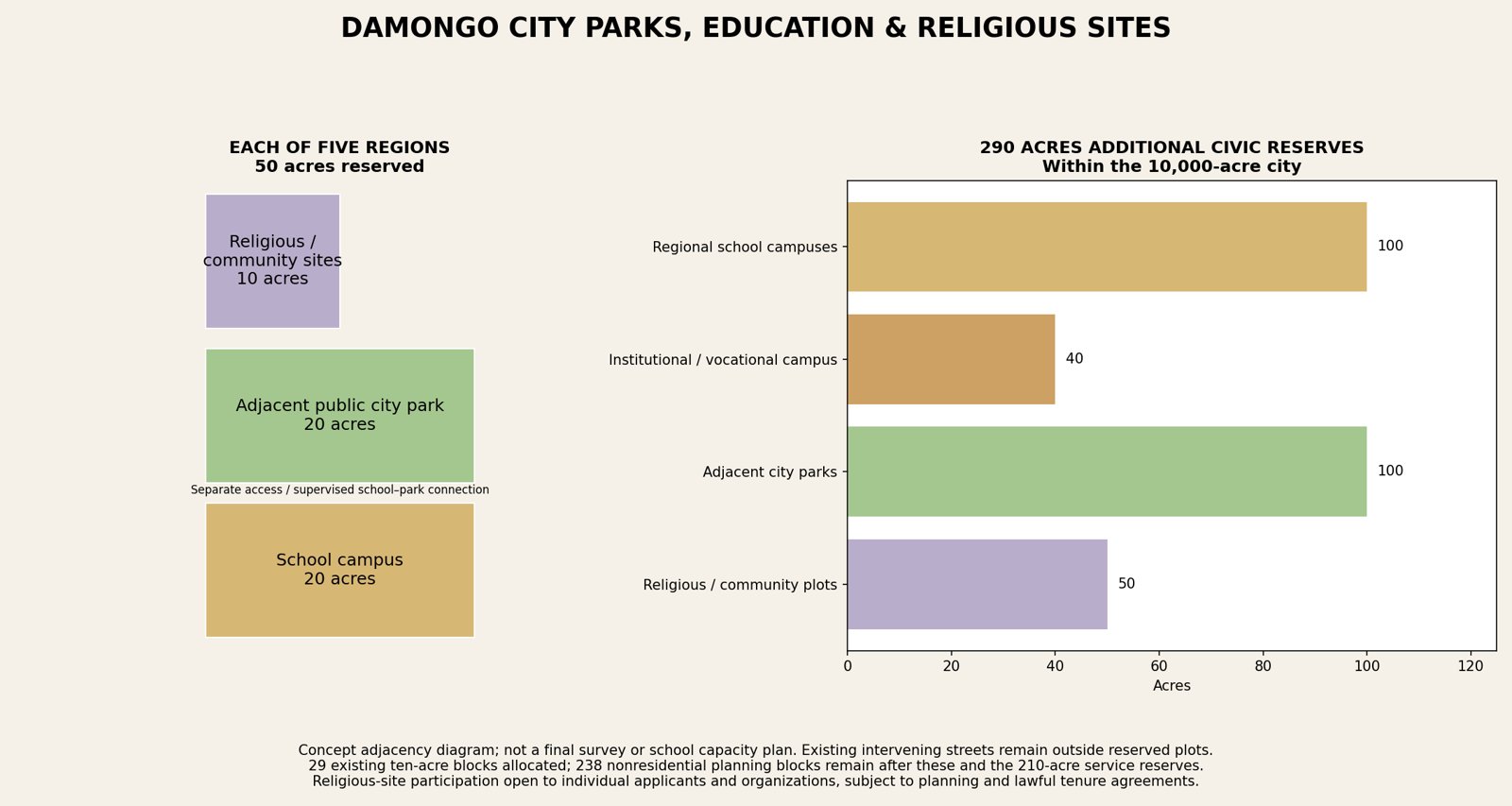
Reserve an additional 290 acres within the existing 10,000-acre city: five 20-acre school campuses (100 acres), a 40-acre institutional/vocational education campus, five adjacent 20-acre neighborhood city parks (100 acres), and five 10-acre religious/community-site reservations (50 acres).
Each school campus adjoins its regional park across an existing local street: conceptual parcels B01, B06, B11, B16 and B21 P07/P08 for schools and P13/P14 for parks, with P19 for religious/community sites. Institutional education is reserved in B25 P07/P08/P13/P14. These are new proposed use designations requiring zoning review.
School campuses can combine primary/secondary education, classrooms, sports, dining and safe drop-off areas; institutional education can host vocational, technical and tertiary programs with labs, workshops and training. Preserve separate public park access and supervised school access; school–park crossings need pedestrian and road-safety design. Enrollment, ages, classroom counts and operating partners are not yet fixed. These five initial campus reservations are not a demonstrated education capacity for the full 490,000-person scenario; additional campuses can be drawn from future reserves.
Religious and community sites are open to applications by individual participants and organizations for proposed land acquisition, long-term lease, or other authorized tenure arrangements. Future subdivision into individual sites is subject to planning, access, utilities and the land-grant agreements. No purchase conveys title before verified legal rights and executed agreements. Allocation is inclusive of different faiths and subject to the same application review; no congregation is assigned by this design.
Land reconciliation: 2,880 acres (288 ten-acre blocks) were retained for nonresidential uses. Regional services consume 210 acres; these parks/education/religious reserves consume 290 acres, leaving 2,380 acres (238 block equivalents), now jointly reserved for the Tema tank-farm development and Damongo Commercial Regional Airport project. New Kingston's existing 800-acre park allocation remains separate, so these 100 acres of neighborhood parks are not double-counted against it. The city total remains 10,000 acres; housing assumptions are unchanged.
Education buildings, religious buildings, landscaping and operating budgets require separate costing and are excluded from the apartment/mall concept totals. Applications express interest only; no site grant, sale or allocation is completed by submission. Visit the Damongo land-use application section.
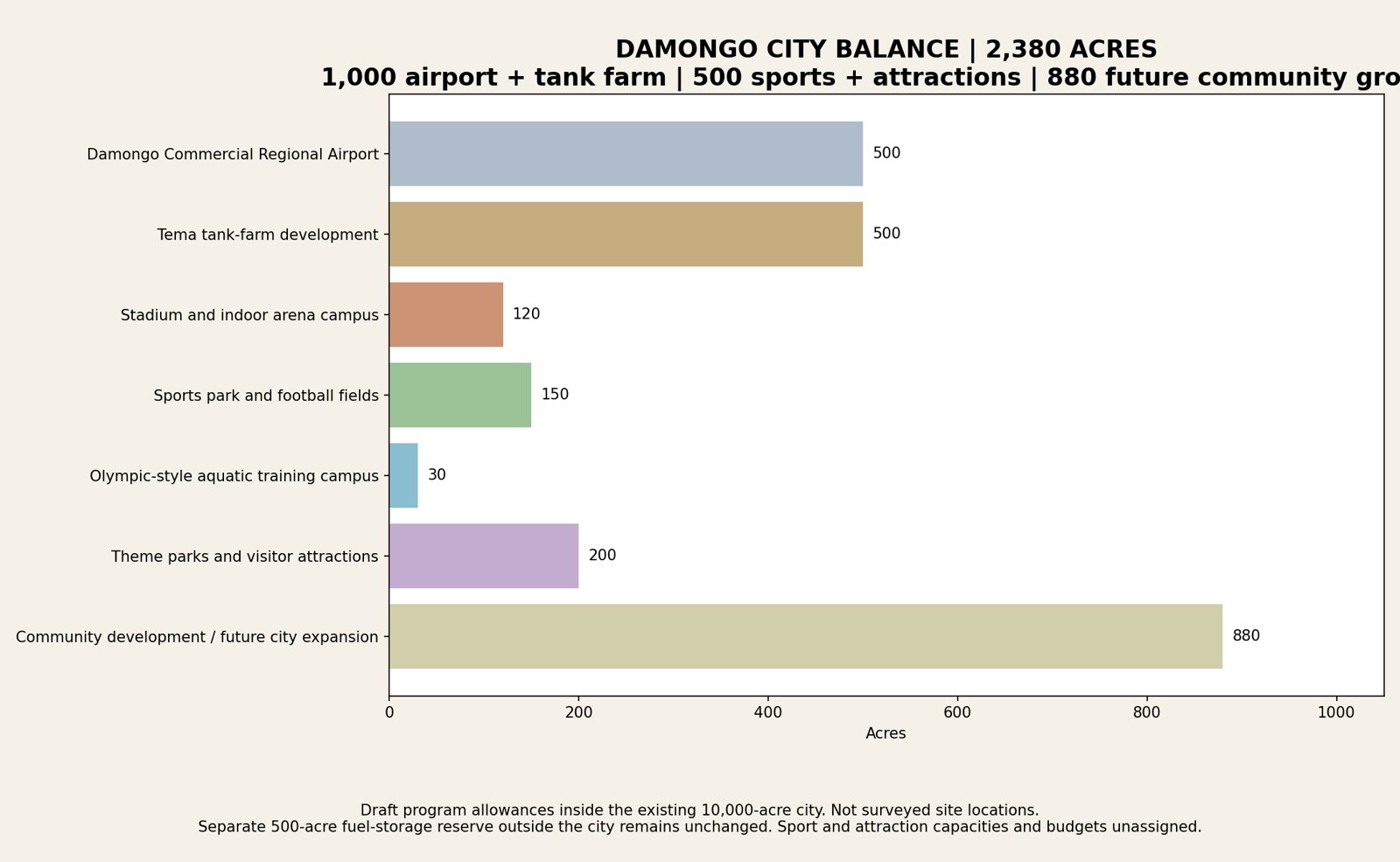
City balance: airport, tank farm, sports, attractions and future growth
The reconciled city balance is 2,380 acres. The latest “2,388” reference is treated as a wording correction, not an eight-acre increase. Confirmed allocation: 500 acres for the Damongo Commercial Regional Airport and 500 acres for the Tema tank-farm development, totaling 1,000 acres inside the city balance. The separate 500-acre fuel-storage reserve outside the city remains recorded.
Draft allocation
Acres
Damongo Commercial Regional Airport
500
Tema tank-farm development
500
Stadium and indoor arena campus
120
Sports park and football fields
150
Olympic-style aquatic training campus
30
Theme parks and visitor attractions
200
Community development / future city expansion
880
Total city balance
2,380
The 1,000-acre airport/tank-farm split is confirmed; the 1,380-acre remainder uses preliminary design allowances: 120 acres for a stadium/indoor arena campus, 150 acres for sports park and football fields, 30 acres for an Olympic-style pool training campus, 200 acres for theme parks/attractions and 880 acres for future community projects and city expansion. These draft suballocations can be refined without changing the city total.
Stadium/arena provision includes event access, athlete areas, parking/loading and ancillary public facilities; seating capacity is not set. Sports park includes football training and match fields, recreation and accessible walking routes. The aquatic campus proposes a 50 m training pool plus warm-up/teaching pools, changing, coaching, plant and visitor access; this is a concept provision, with no claim of Olympic certification. Theme-park and attraction plots can be developed through proposed community/partner projects, subject to planning, operating arrangements and demand.
The 880-acre future reserve is available for community-led development and phased city expansion based on growth. Individual, group and organizational participation can proceed through the existing land-use application and project review process; no plot title, sale or tenure grant is made by this plan. Future changes must reconcile roads, utilities and environmental capacity with the original 10,000 acres.
The earlier designation of the entire 2,380-acre balance jointly for the airport and tank farm is superseded by this schedule. The earlier full-city housing estimate does not include additional homes from the future expansion reserve. Current block grid is a planning placeholder: airport runway/approach geometry, contiguous site assembly, fuel buffers and lake relationships require master-plan redesign. The 500-acre airport allowance is a reservation, not evidence that a particular runway/aircraft capacity fits. Sports, airport, tank-farm and attraction capital/operating budgets are excluded from the previous apartment/mall cost ranges.
Estate land balance and fuel-storage reserve
The retained estate planning area is 31,360 acres (seven miles by seven miles). The latest reference to “35,000-plus acres” is not substituted without a revised survey or land schedule.
Estate allocation
Acres
City development concept
10,000
Separate Tema–Damongo fuel-storage development reserve
500
Remaining estate: agriculture, future industrial and airport-related facilities and other proposed developments
20,860
Estate total
31,360
Inside the 10,000-acre city, 2,380 acres are now allocated as 500 acres for the Tema tank farm, 500 acres for Damongo Commercial Regional Airport, 500 acres for sports/attractions, and 880 acres for future community development and city expansion. The physical sites, runway orientation, approach areas and safety buffers remain unassigned; the city grid requires redesign for these uses. This is a component of the city acreage, not additional estate land. Existing housing assumptions, the New Kingston lake district, service stations, emergency facilities, education, parks and religious-site reservations remain allocated. Revised zoning must determine compatible activities and buffers.
The separate 500-acre fuel-storage reserve is drawn from the 21,360 acres previously outside the city concept, leaving 20,860 acres outside both. It supports the proposed Tema–Damongo fuel-storage project. Site boundary, transport connections, storage capacity and construction budget remain to be defined; no airport, tank capacity or additional project acreage is implied. The Damongo Commercial Regional Airport is now proposed within the combined 2,380-acre city reserve. Additional estate land for approach corridors, expansion or associated facilities would require separate allocation. The 500-acre fuel-storage reserve outside the city remains separate; it is not deducted again from the 2,380 acres. No airport or tank-farm layout or operating capacity is established by this land reservation.
Estate and city figures are concept-planning allocations pending survey and land agreements. Agricultural and industrial allocations require appropriate separation from residential, public water, medical and education uses. Fuel storage and any airport development need separate siting, engineering and approvals. These future projects are outside the earlier residential/mall cost estimates.
Flexible city expansion — 10,000-acre core with additional land as needed
The 10,000-acre city layout is now the first-phase core rather than a fixed development ceiling. Earmark up to 5,000 additional acres from the wider 31,360-acre estate for staged expansion, allowing treatment plants, utility corridors, airport/approach needs, community facilities and future housing/industry to gain land as feasibility and growth require. The 2,000, 4,000 and 5,000-acre scenarios are planning options, not compulsory buildout or a final upper limit.
Additional city land
City envelope
Separate external fuel reserve
Other estate land
None: current core
10,000 acres
500 acres
20,860 acres
2,000 acres
12,000 acres
500 acres
18,860 acres
4,000 acres
14,000 acres
500 acres
16,860 acres
5,000 acres
15,000 acres
500 acres
15,860 acres
Current bookkeeping reserves 5,000 acres for potential expansion, separate from the 10,000-acre core and separate external 500-acre fuel reserve, leaving 15,860 acres unassigned to those reservations. If the city adopts the full 15,000-acre envelope, that same land moves into the city; it is not counted twice. No expansion boundary or extra residential count is drawn yet.
Increase wastewater/solid-waste land beyond initial 30/10-acre allowances when process sizing requires it; reserve additional industrial separation and drainage space. Airport runway, approach and safety land can likewise be enlarged following feasibility. Detailed parcel boundaries and the compatible relationship between airport, fuel storage, lake and neighborhoods govern the expansion layout. The current approximately 490,000-person scenario and infrastructure cost range cover the original 10,000-acre core only. Added housing, utility capacity and infrastructure cost must be recalculated for each expansion phase rather than assumed proportional to acreage.
This section supersedes earlier wording that the city must remain at exactly 10,000 acres. The core allocation tables still reconcile to 10,000 acres; their “no additional acreage” statements refer to those first-phase allocations. Expansion is authorized for concept planning but remains subject to surveyed land, tenure, siting and design requirements.
Waste treatment and city infrastructure
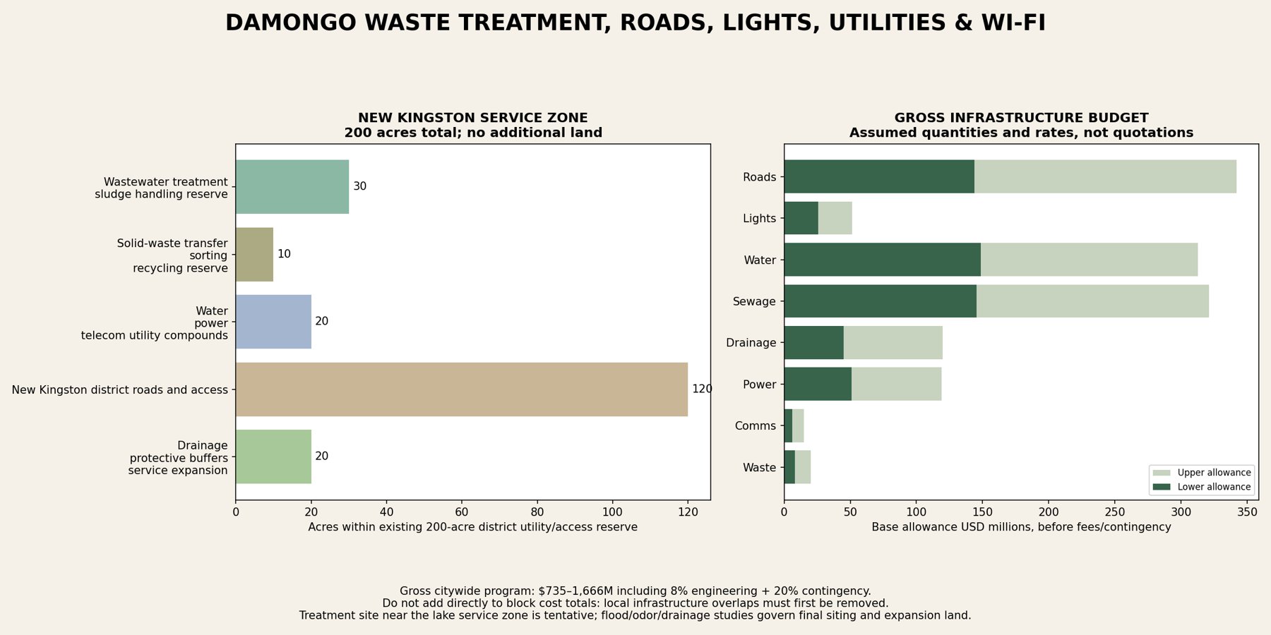
Reserve 30 acres for wastewater treatment/sludge handling and 10 acres for solid-waste transfer, sorting and recycling within New Kingston's existing 200-acre service/access allowance. The remaining allowance is 20 acres for water/power/telecom compounds, 120 acres for district roads/access and 20 acres for drainage, protective buffers and expansion. These are program allowances, not verified facility footprints; the city total remains 10,000 acres. Additional land may be required after process sizing.
Consider a location in the lake-adjacent service zone, with physical separation from recreation and waterfront homes. Lake proximity is not a siting approval: use topography, gravity sewer routing, flood levels, prevailing wind, odors, groundwater and water-quality protection to select the site. No raw sewage, waste leachate or untreated runoff is proposed to enter the lake. Reuse treated water for appropriate nonpotable purposes only after treatment and quality assessment; an outfall route is not selected. Solid-waste land is not a landfill allowance; hazardous, clinical and fuel-related wastes need separate handling arrangements.
Protect treatment assets from flooding and provide backup power, sludge containment, separate stormwater/sanitary systems and secure service access. Technical reference: EPA flood-resilience guidance, used as general engineering context, not Ghana permitting criteria.
Gross citywide infrastructure allowance — USD
System
Draft quantity
Base range
Arterial roads
60.0 km
$60.0–150.0M
Local roads
240.0 km
$84.0–192.0M
Street lighting
10,286.0 fixtures
$25.7–51.4M
Water distribution
300.0 km
$45.0–105.0M
Water treatment / pumping / storage
103.9 ML/day
$103.9–207.7M
Sanitary sewer / pumping
300.0 km
$75.0–180.0M
Wastewater treatment / sludge systems
70.6 ML/day
$70.6–141.2M
Stormwater drainage
300.0 km
$45.0–120.0M
Power distribution / substations
340.6 MW
$51.1–119.2M
Fiber backbone
300.0 km
$4.5–10.5M
Public Wi-Fi nodes
500.0 nodes
$0.5–1.2M
Network core / communications systems
1.0 allowance
$1.0–3.0M
Waste transfer / sorting / recycling facility
1.0 allowance
$8.0–20.0M
Base subtotal
$574.3–1,301.3M
With 8% engineering + 20% contingency, both on base
$735.1–1,665.7M
All quantities and unit rates in the accompanying CSV are analyst-selected planning assumptions, not observed Ghana prices, contractor quotations or measured bills of quantities. Road lengths test 60 km arterial and 240 km local; actual network length and widths require the revised airport/tank-farm master plan. Lighting counts assume two-sided arterial and one-sided local installation at roughly 35 m spacing, not a photometric design. Civil drawings must reconcile right-of-way and existing block service land before final costs.
Water 103.9 ML/day, sewage 70.6 ML/day and electrical load 340.6 MW refer to the earlier approximately 490,000-person full-development scenario. They are average planning loads, not final peak/process capacities. Wastewater cost allowance does not establish that the 30-acre reserve can accommodate that capacity. A staged or decentralized treatment strategy and additional land may be needed. Water-source availability, peak factors and industrial/airport/fuel loads need separate studies. Power costs exclude new generation and upstream grid reinforcement.
Communications provision: fiber along utility corridors, redundant uplinks where available, approximately 500 initial public Wi-Fi nodes, network core, regional service connectivity and separate operational links for emergency services. Household broadband and public Wi-Fi capacity require coverage, spectrum and provider plans. Airtime/backhaul subscriptions, network operations and cybersecurity operating costs are excluded from capital allowances.
This is a gross system-level cost plan. Previous apartment-block budgets already include a 15% local site/services allowance: roads, drains, utilities and lighting must be reconciled against those allowances before creating a consolidated budget. The infrastructure range is not simply added to the earlier block totals. Excludes land, taxes, finance, escalation, operating costs, major abnormal ground/flood works, lake excavation/dams and airport/tank-farm-specific infrastructure. Waste facility equipment is included as a broad allowance; technology and fleet schedules remain unpriced.
Mississauga-inspired residential layout and plot rules
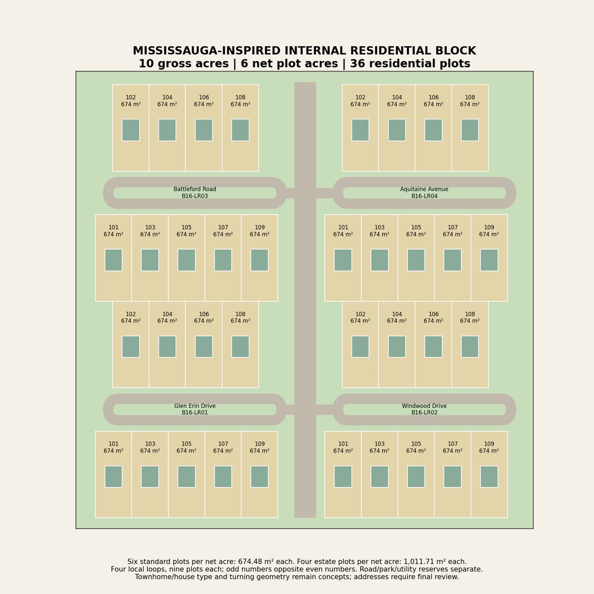
Standard residential land is subdivided into six plots per net plot acre (674.48 m² each); estate land into four plots per net plot acre (1,011.71 m² each). Roads, parks, utility reserves and setbacks are allocated before applying this rate. Gross city acreage is not treated as entirely saleable land.
The revised ten-acre internal block provides six net acres of residential plots and four acres for circulation, green space and services: 36 plots rather than the previous 64 smaller plots. Land budget: 24,281.14 m² plots, 9,000 m² roads/access, 5,000 m² green space and 2,187.42 m² utilities/flexible space. Each plot accommodates a concept 160 m² two-storey home; plot area is not house floor area.
Four loops retain Mississauga-inspired Glen Erin Drive, Windwood Drive, Battleford Road and Aquitaine Avenue, nine plots per loop. Odd addresses 101–109 oppose even addresses 102–108. Each address includes borough, block and unique street ID. Example: 101 Glen Erin Drive, Block D / B16-LR01, Canadaville / Toronto, Zion Trust Damongo City Estates. These are proposed Damongo numbers, not copied Mississauga civic addresses. Local-loop design can be adapted across boroughs with each borough's cultural names; main-street eight-storey commercial frontage is retained separately.
New ten-acre house-block cost: $14.3–19.1M for 36 homes at 160 m² each, using the earlier assumed $1,800–2,400/m² plus 38% local-services/fees/contingency uplift. This is a concept allowance, not a quote. Land, tax, finance and bulk systems excluded. It replaces the earlier 64-home/$25.4–33.9M example. Compared with a 288-home internal apartment block, this option reduces that block's capacity by 252 homes; population, shopping, utilities and total cost must be recalculated for the adopted mix.
Waterfront estate plots now follow four per acre: the existing 20-estate-home option requires five net acres of plots (20,234.28 m²), replacing its former 500 m² plot sizes. Within its ten-acre gross block, retain 1,800 m² tower footprint, 6,000 m² access, 5,000 m² park/promenade, 5,000 m² parking and 2,434.28 m² flexible/utility space; house footprints are within estate plots. Its 196 tower apartments plus 20 estate homes remain the capacity comparison, with 220 m² estate home GFA unchanged. The reduced public-space allowance and actual lot/road fit require waterfront redesign; the old small-estate-plot drawing is superseded.
Mississauga reference source: City Glen Erin road-study map. Original Damongo schematic, pending survey, architecture, drainage, emergency-access and final naming/numbering review.
Townhouse plots, gated villes, full Wi-Fi and off-grid energy
Plot type
Plots per net acre
Plot area
Standard homes
6
674.48 m²
Townhouses
8–10; draft baseline 9
505.86–404.69 m²; baseline 449.65 m²
Estates
4
1,011.71 m²
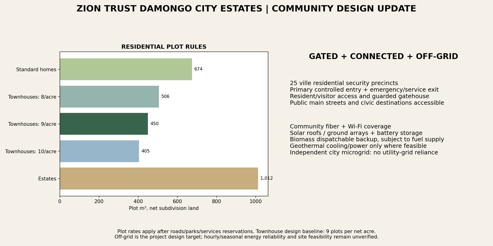
For a ten-acre gross block with six net plot acres, townhouse capacity is 48, 54 or 60 homes at 8, 9 or 10 plots/acre. The existing 36-plot Mississauga schematic is now the standard-home option, not the townhouse option. Use its local-loop and odd/even-numbering approach for the separate townhouse layout; its smaller townhouse parcels and exact drive/parking arrangement still need a drawing. At assumed 160 m² home GFA and earlier $1,800–2,400/m² plus 38% shared allowances, the 54-home townhouse block costs approximately $21.5–28.6M. These analyst allowances exclude land/tax/finance/bulk systems and are not bids. Final adopted unit mix must replace the earlier apartment capacity scenario.
Each ville: gated residential security communities
Each of the 25 ville themes has a proposed residential security precinct, with a primary staffed access gate and a separate emergency/service access point. Use gate IDs Bxx-G01 and Bxx-G02, resident credentials, visitor registration, vehicle queuing, pedestrian access, gatehouse/security patrols and communications. Reserve about 0.5 acre per ville for access/security facilities inside its existing road/service allowances (12.5 acres citywide), subject to final layout; this is not additional plot land. All dwelling clusters, including apartment courts, townhouse compounds and estates, receive controlled entry design. New Kingston's cultural districts may host smaller residential precincts around public facilities.
Public main streets, lake promenade, schools, parks, shopping and regional civic facilities remain publicly accessible through their own entrances; residential security gates do not close the public road network. Emergency responders need independent access, manual override and backup power. Actual boundary fencing, gate sites, staffing and operating costs require the adopted residential site layout. Security arrangements are a design provision, not a guarantee of crime prevention.
Entire community: independent off-grid power
The design brief is a fully off-grid city energy system with no dependence on utility-grid imports. Plan coordinated borough microgrids with solar roofs, ground-mounted solar, grid-forming battery storage, and dispatchable biomass backup. Geothermal is an option only after resource/ground investigations: shallow ground-source cooling is distinct from electricity-generating geothermal, and neither receives a guaranteed electrical output in this model.
Illustrative energy test for the previous 136,224-home core scenario: assume 10 kWh/home/day plus 25% nonresidential allowance, giving 1.703 GWh/day and 71.0 MW average. The earlier 340.6 MW value is a diversified peak assumption, not average energy use. Candidate system: 600 MWp solar (200 rooftop + 400 ground), 1,300 MWh battery nameplate with approximately 1,040 MWh usable at 80% depth of discharge and about 400 MW battery power, plus 40 MW biomass. At an assumed 4 kWh/kWp/day solar yield, output is 2.4 GWh/day before an assumed 20% downstream loss/reserve factor, or 1.92 GWh/day after it. The assumed solar yield is not a measured Damongo forecast.
This test does not establish year-round off-grid reliability: storage provides only about 14.7 average-load hours, and 40 MW biomass does not support the whole assumed 340.6 MW peak or full average load alone. Hourly/seasonal solar, demand, outages, battery cycling, fuel sustainability and extended low-sun periods must determine more storage/generation, load management and critical-load service. Airport, fuel-storage processing, industrial loads and future expansion are additional demand studies. Biomass requires verified feedstock, emissions controls, water and logistics.
Earmark 2,000 acres for candidate 400 MWp ground solar at an assumed 5 acres/MWp, plus 100 acres for energy hubs, from the already reserved 5,000-acre expansion window, leaving 2,900 expansion acres for other needs. Rooftop solar does not add ground acreage. Actual solar row spacing, airport glare/height constraints, fuel separation and utility access must determine siting; these energy reservations are within the estate, not additional land purchases.
Gross generation/storage allowance: $854–1,390M base, or $1,093–1,779M including 8% engineering and 20% contingency. Rates are analyst-selected placeholders: solar $0.7–1.1M/MWp, batteries $0.18–0.30M/MWh, biomass $3–5M/MW, controls/integration $80–140M. No current supplier quote is implied. Distribution/substations remain in the separate infrastructure program; reconcile overlapping controls, fees and on-site services before combining. Excludes land, taxes, finance, geothermal, fuel and ongoing operations, battery replacements and abnormal works. This supersedes any earlier assumption that generation could rely on grid reinforcement.
Community-wide Wi-Fi and communications
Provide fiber backbone and wireless coverage planning for all residential precincts, public destinations, gates and emergency services, powered by the off-grid network. The earlier 500 Wi-Fi nodes are a starting allowance, not evidence of complete coverage. Survey indoor/outdoor signal levels, backhaul availability, subscriber concurrency and resilience; add access points and capacity as needed. Separate resident/guest networks from security and emergency operational systems. Internet connectivity still requires external communications backhaul; electrical independence does not mean isolation from the internet.